
VERDICT
Rua da Conceição, Baixa / Alfama — Lisbon, Portugal
38.7107° N, 9.1365° W (Street-level candidate)
Case #WTP-REAL-LISBON-01 · analyzed in 9s
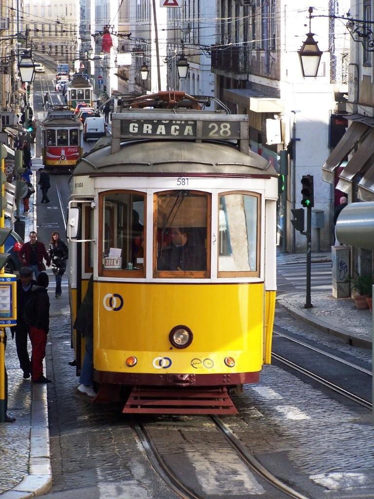
Lisbon Tram · Kevin Gabbert / Kevin James · Public domain
Private image · automatically deleted within 24 hours · never used for training.
- Coordinates
- 38.7107° N, 9.1365° W (Street-level candidate)
- Precision
- Street-level candidate
- Source
- Street scene analysis
GEOGRAPHIC CLUES
6 clues across 4 domains
TEXT & SIGNAGE
Tram signage — The sign reads 'GRAÇA 28', identifying the iconic tourist-heavy tram line that traverses Lisbon's historic hills.
ARCHITECTURE & BUILDINGS
Tram design — The vehicle is a standard Remodelado-series tram, distinctively painted yellow and brown, which is unique to the Carris network in Lisbon.
Wall tiling — The buildings feature 'azulejos', or ceramic tiles, on their facades, which is a hallmark of historical architecture in Lisbon.
TRAFFIC & ROADS
Roadway surface — The ground is paved with 'calçada', a traditional Portuguese pavement technique using small limestone cubes, characteristic of Lisbon's older streets.
INFRASTRUCTURE
Overhead infrastructure — The overhead tram wire support system, spanning from building facade to building facade, is a common solution for narrow medieval streets in cities like Lisbon.
Traffic lights — The style of the traffic light heads and their mounting on slender black poles matches current Portuguese traffic signal standards.
LOCATION INFERENCE
THE DECISIVE CLUE
The destination display reading 'GRAÇA 28' is the decisive clue, as it refers specifically to the most famous tram route in the city of Lisbon, Portugal.
REASONING SUMMARY
The iconic yellow 'Remodelado' tram (number 581) is a primary identifier of the Lisbon electric tram system. The destination sign 'GRAÇA 28' specifically denotes the famous Line 28 route which traverses the steep and narrow streets of Graça and Alfama. The combination of cobblestone streets, ornate wall tiling, and the specific architecture of the buildings confirms this as Lisbon, specifically near the R. da Conceição or R. da Prata areas.
FINAL LOCATION
LOCATION RESULT
Rua da Conceição, Baixa / Alfama — Lisbon, Portugal
38.7107° N, 9.1365° W (Street-level candidate)
CASE NOTES
- ANALYSIS DETAILS
- Model gemini-3.1-flash-lite · analyzed 2026-07-28T04:12:33.815Z in 9s
- REPORT & PRIVACY
- Photo auto-deletes after 24h · never used for training · Case #WTP-REAL-LISBON-01
Coordinate precision follows the evidence-supported location level.
SAVE OR SHARE
Share the reasoningThe owner made this complete case file public, including the candidate map and full clue list.
This public case file has a permanent link you can bookmark or share.